
Places: Everglades | Wilderness Waterway | Chokoloskee Bay | Flamingo Area | Big Bend | Loxahatchee River | Hickey Creek
Withlacoochee River | Alafia River | Estero River | Hillsborough River | Little Manatee River | Peace River
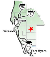
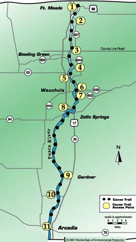
Peace River Canoe Trail
The Peace River Canoe Trail is officially designated as part of Floridaĺs Statewide System of Greenways and Trails. The Spanish, on a map as early as 1544, called it ôRio de la Pazö Ś river of peace. Seminoleĺs called it Tallackchopo (cow peas) because the riverĺs banks were covered with wild peas. The Peace River, true to its name, is a serene, slow-moving river with few signs of civilization. Whether you paddle for a day or a week, the Peace Riverĺs quiet isolation lets you leave big city worries behind. The scars of 19th century phosphate mining of the river banks and bed have been absorbed by the river and lush vegetation.
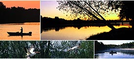
Red-shouldered hawk soar high above moss-draped cypress trees. Turtles slide into the water as a paddler drifts by. Deer and turkey feed in the palmetto thickets. A black bear may wander to the riverĺs edge. Wading birds walk along the bank looking for food while keeping an eye on a nearby alligator. Otter play among the willows. Horizontal cabbage palm dip their trunks in the water before curving straight up so the tops clear the surface. Along its 67 miles, the pale, tea-colored river shows many different faces. Sometimes the river is narrow, passing swiftly between high banks. Around a gentle curve, the river may widen and the current become slow-moving. Past another of the S curves, the river becomes a quiet shallow pond before narrowing again. The Peace River is split by tiny islands and joined by numerous creeks. Sandy beaches and sloping banks provide excellent camping spots.
Mileage: 67
Skill Level: Beginner
Difficulty: Easy (except in high water)
Usual Current: Slow (0-1 mph).
Notes and Precautions
Observe the No Trespassing signs. There is no camping allowed on the east side of the river from Zolfo Springs to Brownville. Also, do not camp on the west side of the river between Gardner and Brownville Bridge. Not many camping sites available below Brownville. Paynes Creek State Historic Site is located .5 mile east of Bowling Green, off SR 664A. An interpretive center, picnicking and nature trails are available. Paddlers may continue downstream. Check maps for additional access points.
Access
- US 98 Bridge ľ At Ft. Meade Recreational Park, one mile east of US 17 off of US 98.
- CR 657 Bridge ľ From US 17, two miles south of Ft. Meade, take CR 657 (Mt. Pisgah Road) southeast one mile to bridge. (3 miles)
- CR 664 Bridge ľ From US 17, .5 mile north of Bowling Green, go one mile on County Line Road to bridge (Paynes Creek Historical Site). (7 miles)
- CR 664-A Bridge ľ From US 17 in Bowling Green, take SR 664-A (Lake Branch Road) east two miles to bridge. (2 miles)
- Lower CR 664-A Bridge ľ In North Wauchula, go south 1.5 miles on US 17 to Rea Road. Turn right (east) and follow Rea Road to intersection with CR 664-A. Turn left (north) on 664-A and go .5 mile to bridge. (4 miles)
- Crews Park Boat Ramp ľ At Wauchula, take SR 64A east to boat ramp. (2 miles)
- CR 652 Bridge ľ At Wauchula, take SR 64-A .5 mile east to CR 652. Turn south on SR 652 and continue to bridge. (1 mile)
- Pioneer Park / Boat Ramp ľ From Wauchula, head south on US 17 to SR 64 in Zolfo Springs. Turn right (west) on SR 64 and look for park and boat ramp. (1 mile)
- Gardner Boat Ramp ľ Take US 17 thirteen miles south of Zolfo Springs. Turn right on River Road, go 1.5 miles to boat ramp. (23 miles)
- Brownville Park -- From Arcadia, take US 17 north approximately four miles to Brownville Street. Take a left (west) and proceed 1.5 miles to entrance. (6 miles)
- SR 70 Bridge ľ From US 17 in Arcadia, head west on SR 70 1.5 miles to bridge. (18 miles)
There may be access points (both public and private) in addition to those listed here. Please remember that some sites require a fee for launching and/or parking.