
Boat Ramps | Freshwater Ramps: Northwest Region | Northeast Region | North Central Region | Southwest Region | South Region
Rentals: Boat Rentals at Naples Bay Resort | Gulf Shores Marina | Marco River Marina |
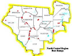
Click on map for an enlarged view
Piers & Boat Ramps
| COUNTY | WATERBODY | PIER LOCATION | BARRIER FREE |
REST- ROOMS |
|---|---|---|---|---|
| Alachua | Lake Johnson | Hawthorne FL. | Yes | Yes |
| Alachua | Lake Lochloosa | Hawthorne FL. | Yes | No |
| Marion | Orange Lake | Gainesville FL. | Yes | No |
| Baker | Ocean Pond | Olustee Osceola National Forest | Yes | Yes |
| Bradford | Lake Sampson -Sampso | Starke FL. | No | No |
| Clay | Lake Asbury | Ronnie Van Zant Park Pond | Yes | Yes |
| Clay | Black Creek | Middleburg | Yes | Yes |
| Clay | St. Johns River | Old Shands Bridge ,Green Cove Springs | Yes | Yes |
| Columbia | Lake Montgomery | Lake City, Baya St. | Yes | No |
| Columbia | Watertown L. | SR 100-Lake City | Yes | No |
| Duval | Pope Duval East & We | W. Beaver St.-Jacksonville | Yes | No |
| Duval | Oceanway Pond | Oceanway Sports Complex-Jacksonville | Yes | Yes |
| Duval | Hanna Park Pond | Hanna Park-Mayport | No | Yes |
| Duval | Crystal Springs Park | Crystal Springs Rd -West Jacksonville | Yes | Yes |
| Duval | Bethesda FMA | I-295/Dunn Ave.Jacksonville | Yes | Yes |
| Duval | Huguenot Pond | S Jacksonville Beach | Yes | Yes |
| Duval | St. Augustine Rd FMA | St. Augustine Rd in E.Central Jacksonville | No | Yes |
| Lafayette | Koon Lake | Four miles east of Mayo | Yes | No |
| Levy | Suwannee R. | Chiefland, Manatee Springs State Park | Yes | Yes |
| Madison | Lake Francis | Madison FL | Yes | No |
| Suwannee | Suwannee Lake | NE of Live Oak | Yes | No |
| Union | Lake Butler | City of Lake Butler | Yes | Yes |
Watermelon Pond (#194)
From Newberry go South
on Hwy 41 for approximately 2.5 miles. Turn
right on SW 46 Ave. Go 1.2 miles to SW 25Oth
St. Turn left. Go 3.6 miles to ramp.
Single-lane ramp with unimproved parking lot capable of accommodating 25 vehicles.
There currently are no FWC boat ramps in Baker County.
Little Lake Santa Fe (#144)
From Starke, go south
on SR 100 for 11.0 miles. Turn right on CR21
for 1 mile. Turn right on 21B and go 2.1 miles.
Ramp is on right side of road.
Double lane ramp. Renovated in 1994. Unimproved parking lot capable of accommodating 20 vehicles. A fishing pier is present.
Black Creek--Middleburg Ramp (#119)
Travel
North on Route 21 from Middleburg, turn right
on CR 220E (Main Street). Go to end of
pavement 1.0 mile to ramp.
Single lane ramp with paved parking lot capable of accommodating 20 vehicles. Bathroom facilities are present, Fishing Pier is present and Bank fishing is allowed.
Black Creek--Rideout Ferry (#46)From Black Creek Bridge in Middleburg, go 1.0 mile north on SR 21 to CR 220. Turn right and travel 3.0 miles to CR 209. Turn right and go 1.8 miles to Old Ferry Road. Turn left and go 0.5 mile to ramp.
Single lane ramp with paved parking lot capable of accommodating 13 vehicles. Bathroom facilities are present.
Lake Brooklyn (#148)From CR 21 in Keystone Heights go north on SR 100 for 0.8 miles. Turn right on King Street and go 0.2 miles to ramp. Ramp is on right side of road.
Single-lane ramp with unimproved parking lot capable of accommodating 20 vehicles.
St. Johns River--Old Shands Bridge (#95)From Green Cove Springs go south on SR 17 for 5.0 miles to 16E. Go east for 2.5 miles to Shands Pier Road. Turn left and follow road 0.3 miles to ramp.
Single-lane ramp with paved parking capable of accommodating 35 vehicles. Bathroom facilities are available and a fishing pier is present.
Governor's Creek--Governor's Creek North (#186)Head north on Rt 17 from Green Cove Springs. Ramp is on right side of road across Governor's Creek Bridge 0.5 mile from downtown.
Fishing observation pier, paved parking lot capable of accommodating 25 vehicles. Universally accessible.
Lake Magnolia--Camp Blanding (#83)From Hwy 100 in Keystone Heights, go north on Hwy 21 for 1.9 miles to paved road entrance to Camp Blanding WMA on the left. Turn left on Treat Road and go 1.5 miles to dirt road on right. Follow dirt road 0.1 mile to ramp.
Public paved ramp.
Lake Lowery--Camp Blanding (#84) From Hwy 100 in Keystone Heights go north 1.9 miles on Hwy 21 to paved road entrance to Camp Blanding WMA on left. Turn left (northwest) on Treat Road for 3.1 miles to dirt road on right. Go 0.4 mile to ramp.Public paved ramp.
Alligator Lake North (#17)
From Rt 90 in Lake
City, go south on US 441 for 1.5 miles to Dot
Road. Turn left and go 0.2 miles to boat ramp.
Single-lane ramp with unimproved parking lot capable of accommodating 20 vehicles. Bank fishing is allowed.
Watertown Lake (#43)From downtown Lake City proceed east on Rt 90 to Junction 100A. Turn left for 0.4 miles to Moose Lodge Road. Turn right and go 0.2 miles to ramp.
Single-lane ramp with paved parking lot capable of accommodating 40 vehicles. Pier and bank fishing are allowed. Barrier free pier.
Santa Fe River--Hollingsworth Bluff (#50)From Ft. White, go south on SR 47 for 4.0 miles. Turn right on Hollingsworth Bluff Road and go 0.75 mile to ramp.
Single-lane ramp with unimproved parking lot capable of accommodating 15 vehicles.
Suwannee River--Goronto Springs (#73)
From
the intersection of SR 351 and 349 go 2.2 miles
to Rock Sink Church Road and turn left. Go
2.4 miles to ramp.
Single-lane ramp with unimproved parking lot capable of accommodating 20 vehicles. Picnicking and camping facilities are present. Bank fishing is allowed.
Suwannee River--Hinton Landing (#41)On Hwy 19 between Old Town and Fannin Springs, take CR 317 south for 2.3 miles to ramp.
Single-lane ramp with unimproved parking lot capable of accommodating 20 vehicles. Bathroom, picnicking and camping facilities are present. Bank fishing is allowed.
Suwannee River--New Pine Landing (#14)From intersection of Hwy 19 and CR 349 in Old Town, go south on CR 349 for 5.1 miles to New Pine Landing Boulevard. Turn left and go 1.2 miles to ramp.
Single-lane ramp with unimproved parking capable of accommodating 12 vehicles. Bathroom, picnicking and primitive camping facilities are present.
Suwannee River--Purvis Landing (#121)From Highway 19 and 98 in Old Town, go north 3.3 miles on SR 349. Turn right on Purvis Landing Road and go 1.5 miles to ramp.
Single-lane ramp with unimproved parking lot capable of accommodating 20 vehicles. Bathroom facilities are present and bank fishing is allowed.
There currently are no FWC boat ramps in Duval County.
Santa Fe River--Tudeen Park (#123)
From Santa
Fe River Bridge on Hwy 49 and SR 129, go
south for 1.0 mile to CR 138. Turn left and go
3.1 miles to Ira Bea Oasis Road (NE 2nd Way).
Turn left and go 2.4 miles to unnamed dirt
road. Turn right 500 yards to ramp.
Single-lane ramp with unimproved parking lot capable of accommodating 5 vehicles. Bank fishing is allowed.
Suwannee River--Eula Landing (#177)From intersection of Hwy 27 and SR 26 in Fanning Springs, go north on SR 26 for 1.3 miles to Wilcox. Turn left on CR 232 and go 5.8 miles to 90 degree right turn in highway. Continue north on SW 70th Ave for 0.5 mile. Turn left for 0.8 mile to SW 25th St. Bear right at fork and go 100 feet to ramp.
Single-lane ramp with unimproved parking lot capable of accommodating 25 vehicles. Bank fishing is allowed.
Suwannee River--Hart Springs Park (#125)From intersection of Hwy 27 and CR 26 in Fanning Springs, go east on SR 26 for 1.3 miles to Wilcox. Turn right on CR 232 and go 4.3 miles to CR 344. Turn left and go 2.0 miles. Bear right at SW 90th Ave. Go 0.5 mile to ramp.
Single-lane ramp with unimproved parking lot capable of accommodating 20 vehicles. Picnic facilities are present and bank fishing is allowed.
Suwannee River--Rock Bluff Springs (#122)Ramp is located at junction of SR 340 at the Suwannee River.
Single-lane ramp. Unimproved parking lot capable of accommodating 20 vehicles. Bathrooms, picnic and primitive camping facilities are available. Bank fishing is allowed.
Suwannee River--Wannee Landing (#124)From intersection of Hwy 27 and SR 26 in Fanning Springs, go north on SR 26 for 1.3 miles to Wilcox. Turn left on CR 232 and go 5.8 miles to 90 degree right turn in highway. Continue north on SW 70th Ave for 2 miles to SW 10 Th St. Turn left for 1.1 miles. Bear right on SW 80th Ave. Go 0.1 mile. Ramp is on left. OR from the north- from CR 340 just east of Suwannee River bridge at Rock Bluff go west 0.5 miles; turn south (right) on CR 340 and go 5 miles. Turn right on SW 10th St.
Single-lane ramp with unimproved parking lot capable of accommodating 20 vehicles. Bank fishing is allowed.
Suwannee River--Nobles Ferry (#9)
From intersection of SR 6 and I-75, go west on SR 6
for 3.3 miles. Turn left on CR 751 and go 3.5
miles. Ramp is on right side of road before
River Bridge Park.
Single-lane ramp with unimproved parking lot capable of accommodating 25 vehicles. Bank fishing is allowed. Primitive camping. No restrooms.
Suwannee River--Hatch Bend (#48)
From
intersection of Hwy 27 and 349, go south on
349 for 4.3 miles. Turn left on CR 342 and
follow the winding road for 2.1 miles to the
junction with CR 342 and 138. Turn left and
go 2.3 miles to ramp.
Single-lane ramp with unimproved parking lot capable of accommodating 30 vehicles. Bank fishing is allowed and picnic facilities are present.
Suwannee River--Mayo Junction/Sand Pond (#22)From the Suwannee River Bridge Crossing at SR 250, go west on CR 250 for 0.7 mile to CR 251. Turn left and go 1.5 miles to Sand Pond Road (no sign). Turn left and continue for 1.5 miles to ramp.
Single-lane ramp with unimproved parking lot capable of accommodating 30 vehicles. Bank fishing is allowed. Picnic facilities present.
Suwannee River--Owen Springs/Ft. McCoombs (#162)From SR 51 in Mayo, go 9.0 miles east on Hwy 27. Turn left at SR 251 for 1.1 miles to paved intersection. Turn right and go 1.3 miles to ramp.
Single-lane ramp with unimproved parking lot capable of accommodating 12 vehicles. Bank fishing is allowed. Picnic facilities are present.
Townsend Pond--Koon Lake (#100)From intersection of Hwy 51 and Hwy 27 in Mayo, go east on Hwy 27 for 3.5 miles. Turn right on CR 354B and go 0.8 mile. Turn right at T-intersection of graded road for 0.4 mile then go left for 0.2 mile. Turn left into park before house and barn. Ramp is in park. Current fishing license stamp required.
Single-lane ramp with unimproved parking lot capable of accommodating 15 vehicles. Universally accessible. Pier and bank fishing allowed. Picnic facilities are present. Bank fishing and barrier free fishing pier present.
Suwannee River--New Clay Landing (#192)
From
intersection of Hwy 19 and SR 320 in
Chiefland, go west on SR 320 for 5.2 miles to
N.W. 110 Avenue. Turn right and go 2.5 miles
to ramp.
Double-lane ramp with courtesy dock. Unimproved parking lot capable of accommodating 20 vehicles. Picnic facilities are available.
Bass Avenue--Lake Rousseau (#47)From intersection of Hwy 19 in Inglis. Go east on SR 40 for 5.9 miles to S.E. 115th Avenue. Turn right and go 0.8 mile. Go left on Bass Boulevard 0.1 mile to ramp.
Single-lane ramp with unimproved parking lot capable of accommodating 20 vehicles. Bank fishing is allowed.
Aucilla River--Seven Bridges (#66)
From
intersection of I-10 and CR 150 in Greenville,
go south on CR 150 for 4.1 miles. Turn right
on graded crossroad before fire tower and go
1.5 miles to ramp.
Single-lane ramp with unimproved parking capable of accommodating 10 vehicles. Bank fishing is allowed. At low water times, river is very shallow.
Lake Francis (#63)From intersection of Hwy 90 and SR 53, go south on SR 53 for 0.3 mile. Turn left onto East Bunker Street and go to lake. Turn left onto Lake Drive and go 0.1 mile to ramp.
Single-lane ramp with unimproved parking capable of accommodating 3 vehicles. Bank fishing is allowed.
Suwannee River--Boundary Bend (#170)From intersection of Rt. 90 and CR 255 in Lee, go south on SR 255 for 8.5 miles to graded crossroad, turn left and go 2.5 miles to second graded crossroad. Go right for 2.5 miles to graded crossroads. Turn left and take left fork towards Mill Creek South, Wildlife Management Area entrance and continue straight on past tower to ramp.
Single-lane ramp with unimproved parking lot capable of accommodating 5 vehicles. Bank fishing is allowed.
St. Mary's River--Walker Landing (#24)
From
Hilliard, go north on US 301 for 7.0 miles to
Boulogne city limits sign. Go 1.1 mile to Lake
Hampton Road and turn right and go 0.7 mile
to unnamed graded road. Turn left and go 0.5
mile to ramp.
Single-lane ramp with paved parking lot capable of accommodating 20 vehicles. Picnic facilities are available and bank fishing is allowed.
Suwannee Lake (#169)
From the Suwannee
County/Columbia County line on Hwy 90 near
Wellborn, travel west on Hwy 90 for 7.5 miles.
Turn right onto CR 417 and go 3.0 miles. Turn
left on 86th Street and go 2.0 miles. Turn right
on 91st Road for 0.3 mile to entrance of Fish
Management area. Turn right and follow park
road 0.3 mile to ramp.
Single-lane ramp with paved parking lot capable of accommodating 60 vehicles. Universally accessible pier and parking space. Pier and bank fishing is allowed. 24 hour access for fishing - must have current fishing license stamp.
Suwannee River--Hollingsworth Park/Royal Springs (#105)From Live Oak, SR 90 and SR 51, go south on SR 51 for 6.0 miles to SR 349. Turn left and go 10.1 miles to 190th Terrace on the right. Turn right and go 0.7 mile to 157th Lane. Turn left and go 0.3 mile to ramp.
Single-lane ramp with unimproved parking lot capable of accommodating 20 vehicles. Bank fishing is allowed.
Suwannee River--Dowling Park (#120)From Hwy 51 in Live Oak, go south 5.0 miles to Hwy 250. Turn right and go 12.1 miles to Suwannee River Bridge Park to ramp.
Picnic facilities are available and bank fishing is allowed. Unimproved parking will accommodate 25 vehicles.
Aucilla River--Nutall Rise (#79)
From Junction of
27-98 in Perry, go west on 98 for 24.6 miles to
Aucilla River. Turn right at first bridge and go
0.2 mile to ramp on left.
Single-lane ramp with unimproved parking lot capable of accommodating 6 vehicles. Bank fishing is allowed.
Econfina River--Hwy 98 (#71)Go 18.3 miles west of Perry on Hwy 98. Ramp is on right on the northeast side of the Econfina River Bridge. Turn right to ramp.
Single-lane ramp with unimproved parking lot capable of accommodating 18 vehicles. Bank fishing is available.
There currently are no FWC boat ramps in Union County.