
Boat Ramps | Freshwater Ramps: Northwest Region | Northeast Region | North Central Region | Southwest Region | South Region
Rentals: Boat Rentals at Naples Bay Resort | Gulf Shores Marina | Marco River Marina |
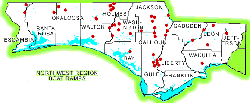
Click on map for an enlarged view
Piers & Boat Ramps
| COUNTY | WATERBODY | PIER LOCATION | BARRIER FREE |
REST- ROOMS |
|---|---|---|---|---|
| Escambia | Lake Stone | Off SR 4 ,SW of Century | Yes | Yes |
| Gadsden | Apalachicola River | Chatahootchee, Florida | No | No |
| Gadsden | Lake Talquin | West side of Talquin End ofHigh Bluff Rd. | Yes | No |
| Gulf | Intercoastal Waterwa | White City | No | No |
| Jefferson | Lake Miccosukee | Hwy. 90- 5 miles W. of Monticello | Yes | No |
| Leon | Lake Talquin | Lake Talquin State Rec. Area | Yes | Yes |
| Okaloosa | Hurricane Lake | 6 miles W. of Blackman | Yes | Yes |
| Santa Rosa | Bear Lake | NE of Munson on SR 4 | Yes | Yes |
Deer Point Lake (#59.) - High Point Landing Boat
Ramp - From Panama City go north on US
Hwy 231 for 6 miles. Turn left on C2321 for
1.5 miles. Turn right on C2311 for 3.5 miles.
Ramp is on left.
Double-lane ramp with paved parking lot capable of accommodating 30 vehicles. Bank fishing is allowed. Picnic facilities are available.
Apalachicola River--Ocheesee Landing (#45)
From Blountstown, go North on SR 69 for 9.0
miles. Turn right on CR 286 AND GO 3.6
miles. Turn right on unnamed dirt road and go
2.5 miles to ramp.
Single-lane ramp with unimproved parking lot capable of accommodating 10 vehicles. Bank fishing and overnight camping is allowed.
Apalachicola River--Red's Landing (#106)
Go
north of Blountstown on SR 69 for 5.3 miles.
Go right on Red's Landing Road (dirt) for 2.2
miles to ramp.
Single-lane ramp with unimproved parking lot capable of accommodating 20 vehicles. Bank fishing and overnight camping allowed.
Chipola River--Chipola Estates Landing (#101)From Altha go west on CR 274 for 4.8 miles. Cross river. Go left on unnamed dirt road for 2.0 miles. Go left on ramp road for 0.5 miles to river.
Single-lane ramp with unimproved parking lot capable or accommodating 2 vehicles.
Chipola River--John Boy Landing (#151)From Altha, go west on CR 274 for 2.7 miles. Turn right on John Boy Road for 1 mile to ramp.
Single-lane ramp with unimproved parking lot capable of accommodating 6 vehicles. Picnic facilities are available.
Cypress Creek (Dead Lakes)--Cypress Creek (#108)Go north of Wewahitchka on Sr 71 for 8.4 miles. Go right on CR 73A for 0.5 miles. Go left on Boat Ramp Road (paved) to ramp.
Single-lane ramp with paved parking lot capable of accommodating 20 vehicles.
Escambia River--McDavid Ramp (#143)
Travel
south of Century on US29 for 7.5 miles. Turn
left on Mystic Springs Road to ramp.
Single-lane ramp with unimproved parking lot capable of accommodating 12 vehicles. Bank fishing is allowed.
Lake Stone Ramp--Lake Stone (#11)From Century, travel south on US29 for 0.5 mile. Turn right on CR4 for 1.5 miles then left on paved drive to ramp.
Single-lane ramp with paved parking lot capable of accommodating 30 vehicles.
Lake Talquin--High Bluff Landing (#115)
From
Midway on SR 268 proceed west 3.0 miles.
Turn left on High Bluff Road 3.5 miles to ramp
at Lake Talquin.
Single-lane ramp with unimproved parking lot capable of accommodating 31 vehicles. Picnicking facilities, pier and bank fishing is allowed.
Ochlockonee River (#33)From intersection of 153 and 157, proceed south on 153 (Old Bainbridge Road) for 0.5 mile to bridge. Ramp is on left before crossing river.
Single-lane ramp with unimproved parking lot capable of accommodating 12 vehicles.
Apalachicola River--Iola Landing (#34)
Go east
of Wewahitchka on C22A for 3.0 miles. Go
left on Iola Road (dirt) 2.5 miles. Go right on
unnamed dirt road 0.5 mile to ramp.
Single-lane ramp with unimproved parking lot capable of accommodating 10 vehicles.
Apalachicola River--Wayside Park (#104)Go east of Wewahitchka on C22A for 4.0 miles. Ramp on left at end of road.
Double-lane ramp with unimproved parking lot capable of accommodating 30 vehicles. Bathroom facilities are present. Picnicking and bank fishing is allowed.
Chipola Cutoff--Land's Landing (#103)Go south of Wewahitchka on SR 71 for 1.0 mile then left on unnamed paved road for 1.0 mile to end of road and ramp.
Single-lane ramp with improved parking lot capable of accommodating 12 vehicles. Universally accessible.
Dead Lakes State Park--Dead Lakes (#1)Go north of Wewahitchka on SR 71 for 0.5 mile. Go right on State Park Road for 0.5 mile to ramp.
Single-lane ramp with unimproved parking lot capable of accommodating 16 vehicles. State Park has entry fee.
Choctawhatchee River--Curry Ferry (#60)
Go
south of Pittman on C179 for 1.0 mile, right on
Curry Ferry Road (dirt) for 2.0 miles. Go right
to ramp.
Single-lane ramp with unimproved parking lot capable of accommodating 10 vehicles. Bank fishing is allowed.
Choctawhatchee River--Old Warehouse Landing (#152)
Go north of Westville on C179A for 9.0 miles, then right on unnamed dirt road for 1.4 miles to ramp.
Single-lane ramp with unimproved parking lot capable of accommodating 10 vehicles. Bank fishing is allowed.
Choctawhatchee River--Ward Landing (#102)Go north of Caryville on C179 for 2.6 miles, then left on Spring Park Road (dirt) for 0.8 mile. Turn right on unnamed dirt road 0.2 mile to ramp.
Single-lane ramp with unimproved parking lot capable of accommodating 6 vehicles. Bank fishing is allowed.
Lake Victor--Lake Victor East (#4)Go west of New Hope on SR 2 for 1.5 miles, then left on dirt road for 0.4 mile. Go right at bait house to ramp.
Single-lane ramp with unimproved parking lot capable of accommodating 5 vehicles.
Lake Victor--Lake Victor West (#3)From New Hope go west on SR 2 for 2.5 miles. Go left on unnamed dirt road for 0.8 mile, Turn left on dirt road for 0.2 mile to ramp.
Single-lane ramp with unimproved parking lot capable of accommodating 3 vehicles. Ramp accessible by small boats only, as it is very shallow.
Chipola River--Magnolia Landing/Veneer
Bridge (#37)
Go south of Marianna on SR 73 for
3.0 miles, then left on CR 280 for 2.0 miles.
Ramp is on right at river intersection.
Single-lane ramp with unimproved parking lot capable of accommodating 8 vehicles.
Chipola River--Peacock Bridge (#113)Go south of Marianna on SR 71 for 10.0 miles, then right on CR 278 for 0.6 mile. Go left on dirt road for 0.1 mile to ramp.
Single-lane ramp with unimproved parking lot capable of accommodating 2 vehicles. Ramp is narrow and water swift.
Chipola River--Yancey Bridge (#107)Go north of Marianna on SR 166 for 1.0 mile. Ramp is on left at intersection of river.
Single-lane ramp with unimproved parking lot capable of accommodating 6 vehicles. River very shallow and accessible only by small boats.
>Compass Lake (#133)Go south of Cottondale on US 231 for 11.5 miles, then left on SR 75 for 2.3 miles. Go left on Lake Road (paved) one block to ramp.
Single-lane ramp with unimproved parking lot capable of accommodating 2 vehicles.
Lake Seminole--Butler Ramp (#131)Go north of Sneads on CR 271 for 7.0 miles. Ramp is on right.
Single-lane ramp with unimproved parking lot capable of accommodating 10 vehicles.
Merritt's Mill Pond (#110)- Travel north of Marianna on SR 71 for 1.0 mile, then right on CR 164 for 1.5 miles. Right on Hunter Fish Camp Road for 0.8 mile to ramp.
Single-lane ramp with unimproved parking lot capable of accommodating 10 vehicles.
Ocheesee Pond--Shady Grove Ramp (#7)Go south of Grand Ridge on SR 69 for 1.0 mile then left on CR 69A for 5.9 miles. Travel left on Shady Grove Road (dirt) for 0.2 mile to ramp.
Single-lane ramp with unimproved parking lot capable of accommodating 15 vehicles.
Lake Miccosukee South--Lake Miccosukee(#182)
Go west of Monticello on US 90 for 6.5 miles.
Ramp is on right across bridge.
Single-lane ramp with unimproved parking lot capable of accommodating 6 vehicles. Universally accessible parking.
Travel north of Tallahassee on US 319 for 15 miles then left on C12 for 2.2 miles. Go left on Lake Iamonia Road for 1.8 miles to ramp.
Single-lane ramp with unimproved parking lot capable of accommodating 25 vehicles.
Lake Munson (#78)
Go south of Tallahassee on SR 61 for 1.0 mile then right on Lake Munson Road 0.2 mile to ramp.
Single-lane ramp with unimproved parking lot capable of accommodating 2 vehicles.
Florida River (#180)
Travel south of Bristol on
C379 for 19.0 miles. Go right on National
Forest Road No. 188 for 1.0 mile to ramp.
Single-lane ramp with unimproved parking lot capable of accommodating 20 vehicles. Universally accessible.
White Oak Landing--River Styx (#184)Go south of Bristol on C379 for 22.0 miles. Go right on National Forest Road No 115 for 3.0 miles to ramp.
Single-lane ramp with unimproved parking lot capable of accommodating 16 vehicles. Universally accessible.
Hurricane Lake--Hurricane Lake South (#39)
Go
west of Baker on SR 4 for 5.0 miles, then right
on Beaver Creek Road for 5.0 miles. Go right
on Hurricane Lake South for 2.5 miles. Turn
left at intersection to ramp.
Single-lane ramp with unimproved parking lot capable of accommodating 25 vehicles. Bathroom and picnic facilities are available and bank fishing is allowed. Paid camping area.
Hurricane Lake--Hurricane Lake North (#40)Go west of Baker on SR 4 for 5.0 miles, right on Beaver Creek Road for 7.5 miles. Right on Hurricane Lake Road North (dirt) for 1.0 mile. Turn left at intersection and go 1.0 mile to ramp.
Single-lane ramp with unimproved parking lot capable of accommodating 20 vehicles. Bathrooms, showers and picnic facilities are available and bank fishing is allowed. Paid primitive camping area.
Karick Lake--Karick Lake North (#150)North of Baker on SR 189 for 7.5 miles. Right on Karick Lake North Road (dirt) for 1.0 mile, then right at intersection for 0.6 mile to ramp.
Single-lane ramp with unimproved parking lot capable of accommodating 25 vehicles. Bathroom, shower and picnic facilities are available and bank fishing is allowed. Paid camping area.
Karick Lake--Karick Lake South (#149)Go north of Baker on SR 189 for 6.8 miles, then right on Karick Lake Road South (dirt) for 1.0 mile to ramp.
Single-lane ramp with unimproved parking lot capable of accommodating 25 vehicles. Bathroom, shower, and picnic facilities are available and bank fishing is allowed. Paid camping area.
From county line go east on SR 4 to Bear Lake Road. Turn right on Bear Lake Road and go 0.5 mile to ramp on right.
Single-lane ramp with paved parking lot capable of accommodating 30 vehicles.
Lake Ellen (#72)
Go south of Crawfordville on
U.S. 319 for 4.0 miles to intersection of U.S. 98.
Go right on U.S. 98 for 0.5 mile then right on
Floyd Gray Road for 1.0 mile to ramp.
Single-lane ramp with unimproved parking lot capable of accommodating 6 vehicles.
Alaqua Creek (#173)
Go west of Freeport on SR20
for 2.5 miles. Ramp is on left at intersection of
SR20 and Alaqua Creek.
Single-lane ramp with unimproved parking lot capable of accommodating 10 vehicles. Bank fishing is allowed.
Choctawhatchee River--Cedar Log (#10)Go south of Ponce De Leon on CR181A for 2.5 miles. Go left on CR181 for 2.1 miles then right on Cedar Log Road (dirt) for 1.3 miles to ramp.
Single-lane ramp with unimproved parking lot capable of accommodating 3 vehicles.
Juniper Lake--Catts Island (#64)Go north of Defuniak Springs on SR83 for 3.8 miles. Turn left on Catts Island Road and go 1.3 miles to ramp.
Single-lane ramp with unimproved parking lot capable of accommodating 16 vehicles. Bathroom and picnic facilities are available and bank fishing is allowed.
Juniper Lake--Juniper Lake Dam (#65)Go north of Defuniak Springs on 83 for 2.5 miles then left on Juniper Lake Road for 0.8 mile to ramp on right.
Single-lane ramp with unimproved parking lot capable of accommodating 20 vehicles. Bathroom and picnic facilities are available and bank fishing is allowed.
Choctawatchee River--Boynton Cutoff (#154)
Go
south of Caryville on CR 279 for 4.0 miles and
right on CR 280 for 4.5 miles. Turn left on CR
284 for 6.0 miles and right on CR 284A for 3.0
miles. Go right on Boynton Cutoff Road (dirt)
for 1.0 mile to ramp.
Single-lane ramp with unimproved parking lot capable of accomodating 5 vehicles. Bank fishing is allowed.
Choctawatchee River--Hinson Crossroads (#134)Go south of Caryville on CR 279 for 4.0 miles then right on CR 280 for 4.5 miles. Go straight across intersection on dirt road for 2.0 miles to ramp.
Single-lane ramp with unimproved parking lot capable of accommodating 15 vehicles. Picnic facilities are available and bank fishing is allowed.
Gap Pond (#132)Go south of Wassau on SR77 for 5.6 miles. Turn left on Sunny Hills Boulevard and go 3.0 miles. Go left on Country Club Drive for 2.0 miles and right on Gap Pond Road for 1.0 mile to ramp.
Single-lane ramp with unimproved parking lot capable of accommodating 5 vehicles.
Holmes Creek--Hightower Springs (#145)Go south of Vernon on SR 279 for 4.0 miles then right on Hightower Springs Road (dirt) for 0.5 mile to ramp.
Single-lane ramp with unimproved parking lot capable of accomodating 6 vehicles. Bank fishing is allowed.
Pate Pond (#89)Go south of Caryville on CR279 for 4.0 miles to intersection of CR280 then south of CR280 for 0.7 mile to ramp on left.
Single-lane ramp with unimproved parking lot capable of accommodating 2 vehicles.
Yates Mill Pond (#58)Go south of Caryville on CR 279 for 4.0 miles then right on CR280 for 4.0 miles. Turn right on ramp road (dirt) for 0.2 mile to ramp.
Single-lane ramp with unimproved parking lot capable of accommodating 12 vehicles. Bank fishing is allowed.
Holmes Creek--End of Canoe TrailGo west of New Hope on SR 284 for 1.3 miles to Hancock Road. Turn right on Hancock and go 1.0 miles. Turn left on Live Oak Landing Road for .05 miles to ramp.
Single-lane ramp with unimproved parking lot capable of accomodating 6 vehicles. Bank fishing is allowed.