
Boat Ramps | Freshwater Ramps: Northwest Region | Northeast Region | North Central Region | Southwest Region | South Region
Rentals: Boat Rentals at Naples Bay Resort | Gulf Shores Marina | Marco River Marina |
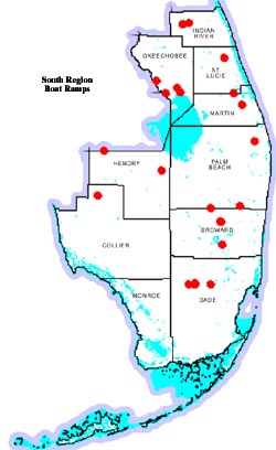
Click on map for an enlarged view

Piers & Boat Ramps
| COUNTY | WATERBODY | PIER LOCATION | BARRIER FREE |
REST- ROOMS |
|---|---|---|---|---|
| Broward | Trade Winds Park Lak | Sample Rd W . of Turnpike | Yes | Yes |
| Broward | C.B. Smith Park Lake | Flamingo Rd N of Pines Blvd. | Yes | Yes |
| Broward | Brian Piccolo Park L | Sheridian Rd. W. of Univer. Dr, Davie | No | No |
| Broward | Delevoe Park Lake | Sistrunk Blvd. E. of N.W. 27 Ave | Yes | Yes |
| Collier | Lake Trafford | Off SR 890 W. of Immokalee | Yes | No |
| Okeechobee | Lake Okeechobee | Off US 441 S. of Okeechobee | Yes | No |
| Palm Beach | Lake Osborne | W. of I-95 & SR 812 in W..P.B. | No | Yes |
| Palm Beach | Lake Ida | W. of I-95 & SR 812 in W.P.B. | Yes | Yes |
| Palm Beach | Okeeheelee L | E. of FL turnpike & SR 882 in W.P.B. | No | Yes |
| Palm Beach | Lake Biwa | Morilami Park-Jog Rd & Linton ,W.P.B. | Yes | Yes |
| Palm Beach | WPB Catchment Lake | N` Lake Blvd 1 mi Wof Bee Line Hwy | No | No |
L-38-E Canal (ECA 3)--Stub Canal (#174)
From
intersection of I-75 and Hwy 27, west of Ft.
Lauderdale, travel north on Hwy 27 for 6.0
miles. Ramp is on right side of road at Stub
Canal access area.
Single-lane ramp with paved parking lot is capable of accommodating 15 vehicles. Picnic facilities are present and bank fishing is allowed.
L-38-W Canal (ECA 3)--Johnnie's Bass Hole (#160)From intersection of I-75 and Hwy 27, west of Ft. Lauderdale. Travel north on Hwy 27 for 14.7 miles. Ramp is on left side of road directly across from the S-7 pump station.
Single-lane ramp with unimproved parking lot capable of accommodating 15 vehicles. Bank fishing is allowed.
L-38-W Canal (ECA 3)--Weasle Trail (#159)From intersection of I-75 and Hwy 27, west of Ft. Lauderdale. Travel north for 6.3 miles on Hwy 27. Ramp is on the left side of the road.
Single-lane ramp with unimproved parking lot capable of accommodating 15 vehicles. Picnic facilities are available and bank fishing is allowed.
L-67-A Canal (ECA 3)--Holiday Park (#176)From intersection of I-75 and Hwy 27 west of Ft. Lauderdale, travel south on Hwy 27 for 6.0 miles. Turn right onto Griffin Road extension. Go 0.6 mile to ramp.
Four-lane ramp with floating courtesy dock. Unimproved parking lot capable of accommodating 20 vehicles. Bathroom, picnic and camping facilities are present. A marina is also on-site. Bank fishing is allowed.
Lake Trafford (#75)
From intersection of SR 29
and Lake Trafford Road in Immokalee, travel
west on Lake Trafford Road 3.0 miles to ramp.
CANAL L-67-C (ECA 3B)--Tamiami Trail (#161)
From intersection of Tamiami Trail and Krome
Avenue West of Miami, travel west on
Tamiami Trail 12.3 miles to Structure S-333.
Turn right onto Levee Road and go 0.5 mile
past FWC Ramp on Canal L-67A and ramp.
Single-lane ramp with unimproved parking lot capable of accommodating 20 vehicles.
Tamiami Canal (#153)From intersection of Tamiami Trail and Krome Avenue(Hwy 997) west of Miami, travel west on Tamiami Trail for 1.3 miles to Structure 334. Turn right and cross over structure. Turn left on Levee Road and go 3.0 miles to ramp. Tamiami Canal (#96)
From intersection of Tamiami Trail and Krome Avenue ( Hwy 997) west of Miami, travel west on Tamiami Trail for 12.3 miles to Structure 333. Turn right onto Levee Road. Cross over structure and go 0.1 mile to ramp. L-29 Canal (ECA 3)--S-12-D Tamiami Trail (#90)
From intersection of Tamiami Trail and Krome Avenue west of Miami, travel west on Tamiami Trail 12.9 miles to Structure S-12-D. Ramp is located 200 yards west of S-12-D on right side of trail.
Single-lane ramp with unimproved parking capable of accommodating 25 vehicles.
L-67C/L-29 Canals (WCA-3A) (#135)From intersection of Tamiami Trail and Krome Avenue west of Miami, travel west on Tamiami Trail 12.3 miles to Structure S-333. Turn right and follow Levee Road 75 yards to ramp.
Single-lane ramp with unimproved parking capable of accommodating 10 vehicles. Ramp is primarily used by air boaters because of marsh.
L-29 Canal (ECA 3) S-12-C Tamiami Trail (#91)From intersection of Tamiami Trail and Krome Avenue west of Miami, travel west on Tamiami Trail 16.0 miles to Structure S-12-C. Ramp is located 200 yards west of S-12-C on right side of trail.
Single-lane ramp with unimproved parking capable of accommodating 25 vehicles.
Caloosahatchee River--LaBelle (#117)
From
Labelle, take SR 29 north 0.6 mile to the
Caloosahatchee River. Cross bridge and turn
left onto CR 78. Go 0.2 mile and turn left into
Wayside Park.
Double-lane ramp with unimproved parking lot capable of accommodating 25 vehicles.
L-1 Canal - L-1--Canal Bridge (#118)From intersection of Hwy 27 and CR 832 in Clewiston, go south 11.9 miles on CR 832 to L-1-Canal and the ramp.
Single-lane ramp with unimproved parking lot capable of accommodating 10 vehicles. Bank fishing is allowed.
Blue Cypress Lake (#12)
From the intersection of
I-95 and SR 60 west of Vero Beach, travel west
on SR 60 for 17.5 miles to Blue Cypress Road.
Turn right and go 4.5 miles to ramp.
Single-lane ramp with unimproved parking lot capable of accommodating 15 vehicles. Bathroom and picnic facilities are available. Pier and bank fishing is allowed. Fish camp and marina are nearby. Fuel is available from marina. Air boats are restricted from using this ramp. Ramp open sunrise to sunset.
St. Johns Marsh--Barney Green (#197) Provides access to the Stick Marsh/Farm 13.From intersection of I-95 and CR 512 west of Sebastian, travel west on CR 512 for 3.1 miles to Fellsmere. Turn right onto Broadway Street and go 0.4 miles to Carolina Avenue. Turn left and go 0.4 mile to 138th Avenue, then right and go 3.4 miles to the C-54 Canal. Before crossing C-54 Bridge turn left onto Fellsmere Grade Road and go 6.2 miles to ramp.
Double-lane ramp with floating courtesy dock. Unimproved parking lot capable of accommodating 150 vehicles with additional parking lot along the roadway.
An alternate map in PDF format is available courtesy of the St. Johns Water Management District , it is referred to by them as the Blue Cypress management area.
Canal C-23--Bessie Creek (#158)
From intersection
of Florida Turnpike at Stuart exit and SR 714,
go west on SR 714 for 2.1 miles. Turn right
onto Boat Ramp Road and go 3.5 miles to
ramp.
Single-lane ramp with unimproved parking capable of accommodating 15 vehicles..
St. Lucie Canal--Phipps Park (#156)From intersection of I-95 and SR 76, go west on SR 76 for 0.6 mile to Locks Road. Turn right and go 1.2 mile to entrance to Phipps Park. Turn right into park and go 0.8 mile to ramp.
Double-lane ramp with unimproved parking capable of accommodating 30 vehicles. Ramp is open 6 a.m. to 7:30 p.m.
Kissimmee River--Platts Bluff (#27)
From
intersection of Hwy 441 and Sr 70 in
Okeechobee, travel west on SR 70 for 8.2
miles. Turn right onto N.W. 128th Avenue and
go 5.7 miles to ramp.
Single-lane ramp with unimproved parking lot capable of accommodating 20 vehicles.
Lake Okeechobee--Culvert 7 (#76)From intersection of Hwy 441 and SR 78 in Okeechobee, travel south on 441 over dike on Levee Road into Jaycee Park. Follow Park Road for 0.5 mile to ramp.
Three-lane ramp with floating courtesy dock. Parking lot capable of accommodating 75 vehicles.
Taylor Creek--End of 4th Street (#55)From intersection of Hwy 441 and SR 70 in Okeechobee, travel south on Hwy 441 for 0.2 mile. Turn left onto S.E. 4th Street to ramp.
Single-lane ramp with paved parking lot capable of accommodating 4 vehicles.
Taylor Creek--Hwy 441 (#172)From intersection of Hwy 441 and SR 78 in Okeechobee, travel south on Hwy 441 for 2.5 miles to Taylor Creek Bridge. Cross bridge and immediately turn right onto Taylor Creek Lock and Access Road. Go 0.2 mile to ramp.
Single-lane ramp with unimproved parking lot capable of accommodating 10 vehicles. Bank fishing is allowed.
Canal C-18 (#139)
From intersection of SR 809
(Military Trail) and SR 710 in West Palm
Beach, travel west on SR 710 for 7.1 miles to
SR 786. Turn right onto SR 786 and go 2.0
miles to C-18 Canal. Ramp is on the left side
of the road.
Single-lane ramp with unimproved parking lot capable of accommodating 25 vehicles. Bank fishing is allowed.
Everglades Water Conservation Area II--Lox Road (#88)From intersection of Hwy 441 and Lox Road (SR 827) west of Boca Raton, travel west on Lox Road for 6.3 miles. Turn left on the L-36 Levee Road just before entrance into Loxahatchee National Wildlife Refuge. Go 0.4 miles to ramp.
Single-lane ramp with unimproved parking lot capable of accommodating 25 vehicles. This area is useable by airboats only.
Canal C-25--Belcher Canal (Angle Road) (#155)
From intersection of Florida Turnpike at the Ft.
Pierce exit and SR 713, travel north on SR 713
for 4.1 miles to Angle Road. Turn left and go
1.4 miles to ramp.
Single-lane ramp with unimproved parking lot capable of accommodating 15 vehicles. Bank fishing is allowed.